


Inspired for an Adventure? Check out Beef Stroganoff - Pouch and Beef Stew - Pouch
Free Ground Shipping On All Orders


The use of smartphones out in the wilderness is controversial, but there’s no question that the technology has real utility. Even if you’re against the regular use of a smartphone on your backpacking or paddling, or hunting adventures, it’s not a bad idea to have one stowed away in the pack: If nothing else, it’s another emergency tool in case you run into trouble.

But there’s much else to take advantage of, outdoors-wise, with today’s immensely powerful mobile devices. (And, incidentally, a 2021 survey of 560 thru-hikers on the Pacific Crest Trail found that 97% carried smartphones, many for navigation, even in deep backcountry.) Smartphone apps can deliver you instant trailside flower guides, birdsong identifiers, celestial charts—and, most notably of all, map apps and other navigational references for both staying oriented and recording your own movements through the backcountry.
Here we’re going to round up some of the best hiking apps for offline navigation on the market: programs that serve up topographic charts, satellite images, trail guides, and other resources even when you’re outside the realm of cellular or data coverage. And if you’ve got the bug for wild places—and we imagine that describes an awful lot of our readership here at Mountain House —you’re going to find yourself outside of that realm more than once.
A Quick (but Important) Caveat Off the Bat
Don’t rely on your smartphone alone for backcountry navigation (or emergency signaling, or anything else for that matter). Gadgets and the apps aren’t replacements for hard-copy topographic maps and a compass. Digital technology can and will malfunction, so you’re going to want some good old-fashioned backup at the ready in the event the screen goes screwy or your battery life runs dry. Learning to use both a compass and a GPS hiking app to map your own route will deepen your navigational prowess, not to mention your appreciation for the ground you’ve covered and the terrain around you.
7 Hiking Apps with Offline Map Capabilities
So, without further ado, here are some of our absolute fave outdoor navigation apps!
1. Outdooractive (formerly ViewRanger) - for iOS, Android

ViewRanger was once one of the most trusted offline navigation apps for hikers, known for its detailed topo maps that labeled the peaks, passes, rivers, and lakes you were looking at through the viewfinder, GPS route tracking, and innovative Skyline augmented-reality feature. It allowed users to download maps for offline use, record hikes, and identify landmarks through their phone’s camera, making it a favorite among backcountry adventurers.
In 2022, ViewRanger officially merged with Outdooractive, a European-based mapping platform that now carries on its legacy. Outdooractive includes many of the same tools and features that made ViewRanger popular, along with updated map layers, route planning, and community-shared trails. While the original ViewRanger app is no longer supported, Outdooractive is its modern successor and continues to provide excellent offline navigation, hiking routes, and detailed topographic maps for explorers worldwide.

2. Backcountry Navigator - for Android

Among the best hiking apps Android offers, Backcountry Navigator operates on both smartphones and tablets. With pre-downloaded maps, it works offline as an alternative to a traditional GPS: displaying topo charts, logging waypoints and routes, and much more.
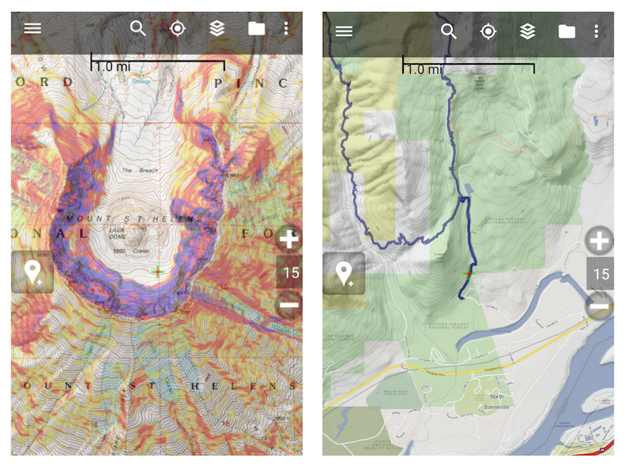
3. Gaia GPS - for iOS, Android
![]()
With apps available for both iOS and Android users, Gaia GPS is another fantastic app with among the best offline navigation capabilities. Cross-reference between USGS/USFS maps, National Geographic Trails Illustrated maps, road maps, and satellite views; define pre-planned routes and chart your on-the-ground travels and waypoints; and link up geologged photos to document your journey.

4. Chimaini National Parks - for iOS, Android

Some of the finest outdoor experiences to be had in the United States await, of course, in the country’s stellar network of national parks. With Chimaini (compatible with both iOS and Android systems), you get a GPS hiking app with onboard maps for more than 70 of America’s national parks—plus trail descriptions, points of interest, recommended destinations, overviews of services, and other handy-dandy information.
5. onX - for iOS, Android

onX Maps is a versatile outdoor mapping and navigation app designed for hikers, backpackers, off-road riders, hunters, and anglers. The platform offers tailored versions for different activities, with detailed topographic data across the U.S. and beyond.
It includes trail data, elevation profiles, and route tracking to help you explore confidently off the grid.
6. AllTrails - for iOS, Android
With AllTrails, you have better than 50,000 trail maps at your fingertips (whether you’re using the iPhone or the Android): an excellent resource for dreaming up your next adventure and then carrying it out with loads of navigational and informational support at your disposal. You can also customize maps to chronicle and share your own personal adventure.
While AllTrails is free to download and use, offline map access is only available through the AllTrails+ subscription (formerly AllTrails Pro). The free version lets you view and record hiking trails when you have cell service, but if you’re heading into areas without reception, upgrading is worth it. With AllTrails+, you can download maps for offline use, get wrong-turn alerts, and enjoy extra features like 3D map views—making it a great choice for serious hikers and backcountry adventurers.
7. Organic Maps - for iOS, Android
If you want a simple and reliable hiking app that works completely offline, Organic Maps is a standout choice. This open-source app offers detailed topographic maps, GPS tracking, and trail navigation without ads or data tracking. Once you download your maps ahead of time, Organic Maps works anywhere, even deep in the backcountry where there is no cell service.
It is easy to use and completely free, making it a great option for hikers who want dependable navigation without paying for a subscription. Whether you are planning a weekend hike or a multi-day backpacking trip, Organic Maps keeps you on the right path.
Motion X GPS - for iOS
Before smartphones became loaded with hiking apps, MotionX GPS was a pioneer in mobile navigation. It offered reliable offline maps, GPS tracking, and waypoint features long before many of today’s popular apps existed. For years, it was a favorite among backcountry adventurers.
However, MotionX GPS has since been discontinued and is no longer available for download or active support. Existing users may still be able to access the app if it’s already installed, but it hasn’t received updates in several years.
Free Hiking Apps with Offline Maps
Free hiking apps with offline maps are rare, especially trustworthy ones, but you do have some options. While many free apps advertise offline features, most require a paid upgrade to unlock full access to maps when you’re off the grid.
-
Although they do not offer access to their own offline maps in their free model, Gaia GPS does allow you to upload other offline GPX files, which you can find online.
-
Organic Maps is another great free choice. It’s an open-source app based on OpenStreetMap data.
-
Hiiker.app is completely free and has thousands of detailed trail maps.
Whether you choose one of these apps or something different, keep in mind that any free hiking app with offline maps needs to be accurate and stable to ensure safety and accessibility in the wilderness.
So there you have it: some of the best hiking apps for Android, iOS, and Windows smartphone technology. Ready to hit the trail? Download one of these offline hiking apps, grab your favorite Mountain House meal, and set out on your next adventure with confidence—no signal required.

Best Backpacking Trails in Rocky Mountain National Park by Skill Level
One of the highest-elevation national parks in the U.S. and also among the most visited, Rocky Mountain National Park is also, without question, an absolutely world-class destin...
Read more


70+ Best Backpacking Meal Ideas for Your Next Adventure
Many beginner backpackers find meal planning and backcountry cooking to be the most confusing and challenging part of backpacking in general. After all, food is the powerhouse f...
Read more


Join the adventure


©2025 Mountain House — All Rights Reserved.