Inspired for an Adventure? Check out Beef Stroganoff - Pouch and Beef Stew - Pouch
Free Ground Shipping On All Orders
Over 2,100 Reviews
Add description, images, menus and links to your mega menu
A column with no settings can be used as a spacer
Link to your collections, sales and even external links
Add up to five columns
Add description, images, menus and links to your mega menu
A column with no settings can be used as a spacer
Link to your collections, sales and even external links
Add up to five columns
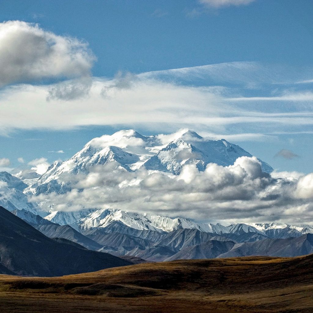

The U.S. is home to a massive selection of mountain ranges, many of which are not particularly skyscraping. Just look at the lake-spangled Adirondacks, the craggy Guadalupes, and the bouldery Wichitas. That’s not to say, though, that America doesn’t have its fair share of tantalizingly tall alpine crests: real up-in-the-clouds, thin-air kinds of heights, calling to stout-calved and big-lunged hikers, backpackers, and climbers.
What Are the Top 10 Tallest Mountains in the United States?
If you’re looking to hike or climb the tallest mountain peaks in the United States, Alaska is where you want to start. Incredibly, all 10 of the tallest U.S. mountains reside there, which include:
- Denali (Mount McKinley) - Alaska Range - 20,310 ft.
- Mount Saint Elias - Saint Elias Mountains - 18,009 ft.
- Mount Foraker - Alaska Range - 17,400 ft.
- Mount Bona - Saint Elias Mountains - 16,550 ft.
- Mount Blackburn - Wrangell Mountains - 16,390 ft.
- Mount Sanford - Wrangell Mountains - 16,237 ft.
- Mount Fairweather - Saint Elias Mountains - 15,325 ft.
- Mount Hubbard - Saint Elias Mountains - 14,951 ft.
- Mount Bear - Saint Elias Mountains - 14,831 ft.
- Mount Hunter - Alaska Range - 14,573 ft.
If you’re looking more at mountain ranges as a whole, there are many other towering ranges across the U.S. to consider visiting beyond those found in Alaska. Below, we provide information and interesting facts about the top 10 highest mountain ranges in the United States.
(1) ALASKA RANGE (ALASKA)

One of the world’s greatest mountain masterpieces resides in the U.S. state of Alaska and is known as the Alaska Range. It bows across some 600 miles of south-central Alaska, arcing between the Yukon border and the Alaskan Peninsula’s Aleutian Mountains. Formed by the subduction of the Pacific Plate under the North American mainland and dominated by the big granitic bodies called batholiths, these fault-struck mountains are still rising. While the range averages some 7,000 to 9,000 feet high, its central section stretches much, much higher into the sky. The Alaska Range is home to several of the top 10 tallest mountains in the U.S.
The king peak is the massive, 20,310-foot Denali. It takes the throne for having the highest mountain peak in the U.S. and North America as a whole, rising roughly 3000 feet higher than Mount Everest from base to summit. Denali is a challenging climb that attracts over 1,200 mountaineers from around the world per year, with a success rate for climbers reaching the highest point hovering around 50 to 60%. Its north face—the Wickersham Wall, rising more than 14,000 feet—ranks among the grandest mountain faces on Earth, perhaps second only to Nanga Parbat’s Rupal Face in the Himalayas. The other highest Alaska Range peaks are 17,400-foot Mount Foraker (third-tallest mountain in the U.S.), 14,573-foot Mount Hunter (tenth-tallest mountain in the U.S.), and 13,832-foot Mount Hayes.
Boreal forest laps against the margins of the Alaska Range, but while conifers string along the lower valleys, the flanks of the range are mostly quilted in tundra; glacial ice and permanent snowpack cover much of the heights. Visitors to Denali National Park & Preserve hope for those rare clear views of Denali itself, but also often spot typical Alaska Range wildlife: from Dall sheep, caribou, and moose to grizzlies, wolves, lynx, and wolverine.
The Alaska Range is certainly among the best mountain ranges in the U.S. for mountaineering and climbing, given its Himalayan-like scale and singular challenges: Climbers tackling such goals as Denali, Foraker, or the far-flung towers of the Kichatna Spires contend with some of the roughest weather anywhere.
(2) SAINT ELIAS MOUNTAINS (ALASKA/CANADA)

The highest coastal range on the planet, the Saint Elias Mountains shared by the U.S. and Canada can be thought of as the topographic pinnacle of the vast, subduction-driven mountain system edging the Pacific along North America’s western margin. The tallest peak here is 19,551-foot Mount Logan in Yukon—Canada’s highest mountain—while the second-tallest, Mount Saint Elias on the Alaska-Yukon border, is also the No. 2 peak in both countries. Mount Saint Elias is a stunner: Its storm-pounded summit rears to 18,009 feet a mere 10 miles from Icy Bay’s saltwater.
The Saint Elias Mountains include a number of other peaks jutting past the 16,000-foot contour, among them 16,550-foot Mount Bona in Alaska—the fourth-highest peak in the U.S. and the country’s tallest volcano (part of the Wrangell Volcanic Field). Another notable landmark here is the 15,325-foot Mount Fairweather (which is the seventh-tallest mountain in the U.S. and can definitely be thought of as ironically named) split by Alaska and British Columbia, and the latter province’s crowning peak. The Saint Elias Range is also home to the eighth-tallest mountain in the United States, Mount Hubbard at 14,951 feet, and the ninth-tallest, Mount Bear at 14,831 feet.
Hosting sparse forest and expansive tundra, the Saint Elias Mountains include the greatest swaddling of non-polar icefields in the world, feeding such epic glaciers as the Malaspina (bigger than Rhode Island). Mountain goats, Dall sheep, caribou, moose, grizzlies, black bears, and wolves are only some of the wildlife here, while a rich lineup of marine mammals ply the brine within view of the Saint Elias skyline.
These mountains belong to one of the world’s wildest and most extensive protected complexes: the UNESCO World Heritage Site of Kluane/Wrangell-St. Elias/Glacier Bay/Tatshenshini-Alsek, which covers some 38,000 square miles along the U.S.-Canada line.
(3) WRANGELL MOUNTAINS (ALASKA)

The Wrangells adjoin the Saint Elias Mountains to the west and much of their high, rugged, ice-mantled acreage lies within the biggest national park in America (and part of that aforementioned UNESCO site), the roughly 20,588-square-mile Wrangell-St. Elias National Park & Preserve. Some supersized volcanoes of the Wrangell Volcanic Field compose the range’s highest peaks, including 16,390-foot Mount Blackburn (fifth-tallest U.S. mountain), 16,237-foot Mount Sanford (sixth-tallest U.S. mountain), and 14,163-foot Mount Wrangell.
Vegetation in the Wrangells ranges from spruce forest to alpine tundra, while the same megafauna-heavy wildlife roster of the Saint Elias Range can be found in this vast wild mountainscape. Wrangell-St. Elias National Park & Preserve also contains the largest contiguous wilderness area in the U.S.: the 9,078,675-acre Wrangell-St. Elias Wilderness.
(4) SIERRA NEVADA (CALIFORNIA)

California’s “Range of Light,” as John Muir called the Sierra Nevada, includes the highest peak in the Lower 48: 14,505-foot Mount Whitney, located in the beautiful Sequoia National Park. Along with being the highest mountain in the contiguous United States, Whitney is also part of the so-called Muir Crest, one of the two crowning mountain groups of this 400-plus-mile-long range, each containing half a dozen Fourteeners; the other group, the Palisade Crest, tops out with 14,242-foot North Palisade. These are in the Central and Southern Sierra, the elevational culmination of the Sierra Nevada; for 90 or so miles between Duck and Trail passes, the crest of the range stays above 11,000 feet.
As Stephen Whitney notes in a still-sturdy classic, A Sierra Club Naturalist’s Guide to the Sierra Nevada, the Sierra Nevada can be considered the longest contiguous mountain range in the Lower 48. The Appalachians, Rockies, and Cascades are much lengthier, technically, but the first two are separated into many individual subranges by intervening valleys and basins, and the roughly 700-mile-long Cascades are cut clear through by several major gorges.
Most famous for the pale, sparkling granitic domes and rocklands of the Sierra Batholith but also including dark volcanic rock, the Sierra Nevada is host to some of the world’s grandest alpine scenery. It also grows absolutely superlative conifer forests of tremendous diversity and stature. Its public lands include internationally renowned destinations such as Yosemite and Sequoia-Kings Canyon national parks. And a nearly 200-mile-long stretch of the High Sierra crest between Yosemite and the Sequoia National Forest isn’t crossed by a road, forming a major belt of high-elevation backcountry.
(5) SAWATCH RANGE (COLORADO)

Nestled in the heart of the Southern Rocky Mountains, Colorado’s Sawatch Range ranks as the highest in the entire Rockies. The range, the better part of 100 miles long, plays host to a slew of Fourteeners, including the Rocky Mountain high point of 14,440-foot Mount Elbert as well as 14,428-foot Mount Massive, 14,421-foot Mount Harvard, and 14,343-foot La Plata Peak (the last two part of the Collegiate Peaks). Another notable summit here is the 14,011-foot Mount of the Holy Cross, named for its distinctive northeastern snowfield.
Besides the mostly non-technical climbing of its great peaks, the Sawatch offers plenty of other outdoor recreation within the San Isabel and White River national forests. These peaks help feed the headwaters of one of the Mississippi’s longest tributaries, the Arkansas, which rages through celebrated whitewater gorges within shouting distance of the Sawatch snowfields.
(6) CASCADE RANGE (WASHINGTON/OREGON/CALIFORNIA)

The tempestuous Cascade Range of the Northwest, part of the Pacific Ring of Fire, includes singularly striking mountain scenery, though much of it—particularly in the Central and Southern Cascades—manifests not as a dense phalanx of rocky summits but as giant, isolated alpine behemoths, primarily stratovolcanoes, looming out of a much lower sea of forested highlands. Washington’s gigantic Mount Rainier crowns the range at 14,411 feet, suited up in some 35 square miles of glacial ice and sending the Lower 48’s lowest-elevation glacier, the Carbon, down to just 3,600 feet above sea level. But Northern California’s 14,162-foot Mount Shasta is a very worthy runner-up Cascadian summit, its 85 cubic miles of lava rock making it even more voluminous than Rainier.
The North Cascades, which broaden this north-south mountain chain out in northern Washington and spill over into southern British Columbia, include the range’s third-highest peak, 12,276-foot Mount Adams, and also its most spectacular alpine scenery; these jagged fangs and ice-capped massifs constitute not only one of the most beautiful mountain ranges in the U.S. but also arguably the steepest.
From appreciating the enormous Douglas Firs, Western Redcedars, and other hulking temperate-rainforest conifers of the west-slope Cascades to summiting Rainier, Shasta, Adams, Hood, and other stratovolcano beacons, the Cascades are a genuine outdoor playground with plenty of adventures to be had (and also happen to be Mountain House’s backyard!).
(7) SANGRE DE CRISTO RANGE (COLORADO)

Part of the broader uplift of the Sangre de Cristo Mountains—which run down into New Mexico as the southernmost range of the Rockies—the Sangre de Cristo Range is the second-highest in the Rocky Mountains, rising to 14,351 feet on Blanca Peak and 14,300 feet on Crestone Peak. Named the “Blood of Christ” mountains by Spanish explorers on account of their alpenglow, the Sangre de Cristos are also notable for the huge sand dunes banked up against their foothills, the centerpiece of Great Sand Dunes National Monument.
(8) SAN JUAN MOUNTAINS (COLORADO)
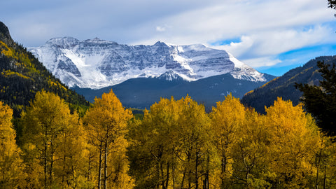
The enormous San Juan Mountains of the Southern Rockies form a super-impressive expanse of above-timberline country and some notable reservoirs of true Colorado wilderness. Among the San Juans’ notable share of Fourteeners are such head-turning peaks as Uncompahgre (the 14,321-foot horn topping the range) and iconic Mount Sneffels (14,158 feet). But Fourteeners don’t account for all of the San Juans’ recognizable landmarks: Others include the dramatic ramparts of 12,152-foot Courthouse Mountain and 11,781-foot Chimney Rock in the Cimarron subrange around Owl Creek Pass, the remote and majestic Rio Grande Pyramid (13,827 feet) and the nearby Window notch, and the tuff hoodoos of the Wheeler Geologic Area.
Headwaters of the mighty Rio Grande, the San Juans include extensive (and beautiful) exposures of both sedimentary and volcanic rocks, including the eroded remnants of some pretty whopping prehistoric eruptions. They also account for a passel of big wilderness areas, including Colorado’s largest: the 500,000-acre Weminuche.
(9) TENMILE-MOSQUITO RANGE (COLORADO)

The Tenmile and Mosquito ranges are essentially one and the same—the Tenmile is the smaller northern end, while the larger Mosquito Range is to the immediate south beyond Hoosier Pass, easing down toward the Arkansas Hills—and so are generally lumped together as one group paralleling the Sawatch Range to the west. The Tenmile-Mosquito Range includes a number of Fourteeners, the highest peaks being 14,286-foot Mount Lincoln, 14-272-foot Quandary Peak, and 14,172-foot Mount Bross. This Southern Rockies divide, which edges the western side of South Park, is probably best known for containing the Breckenridge Ski Resort, though it’s also notable among geography buffs for harboring, in the Tenmile portion, the highest named lake in the country: Pacific Tarn, reflecting the clouds way up at 13,420 feet.
(10) ELK MOUNTAINS (COLORADO)
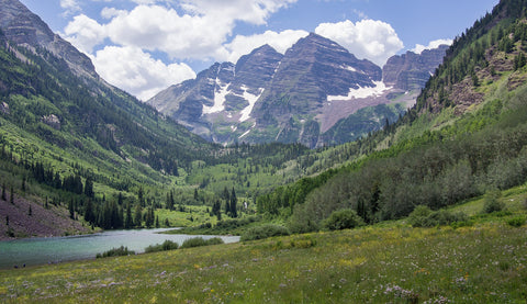
Rounding out our list, the Elk Mountains aren’t Colorado’s highest Rocky Mountain range, but they may just be the most sublime. No question they’re among the best known: The dreamy Maroon Bells—14,156-foot Maroon Peak and 14,019-foot North Maroon—are claimed to be the most photographed peaks in the state, and show off the reddish sedimentary roof well on display in the Elk Mountains. The range’s high point is 14,265-foot Castle Peak; other significant Fourteeners include 14,130-foot Capitol Peak and 14,014-foot Snowmass Mountain. The Maroon Bells-Snowmass Wilderness is a classic hiking and backpacking destination here.
HONORABLE MENTIONS
The San Miguel Mountains of the Colorado Rockies and the White Mountains of California both have a 14,252-foot peak that makes them neck-and-neck as the next-highest range after the Elk Mountains: Mount Wilson in the San Miguels, White Mountain Peak in the Whites. The White Mountains have the further distinction of being the only range in the Lower 48 outside of the Southern Rockies, the Sierra Nevada, and the Cascades with a Fourteener.
We also need to give the eastern U.S. some love: The highest peaks east of the Mississippi reside in several burly ranges of the Southern Appalachians in North Carolina and Tennessee, capped by 6,684-foot Mount Mitchell and 6,647-foot Mount Craig in the Black Mountains and 6,643-foot Clingmans Dome in the Great Smoky Mountains. The Southern Appalachians include dozens of “Southern Sixers,” peaks in excess of 6,000 feet; outside of that region, the only “Sixer” anywhere else in the Appalachians is 6,288-foot Mount Washington in New Hampshire’s Presidential Range.
Finally, a shout-out to the two gargantuan shield volcanoes of the Big Island of Hawaii, which the U.S. Geological Survey terms the largest mountains on the planet. Mauna Kea rises to 13,803 feet above sea level, but when considered from its underwater base to its domelike summit, the peak stands close to 33,500 feet tall, putting Everest to shame. Its neighbor Mauna Loa is a little bit lower, but it’s more massive: It’s the heftiest subaerial volcano in the world, and among any single volcanic edifice it’s out-bulked only by the submarine Tamu Massif.
EXPLORE THE MAJOR MOUNTAIN RANGES IN THE U.S. WITH MOUNTAIN HOUSE EATS!
Trekking the tallest mountain ranges in the U.S. requires the proper fuel, whether a delish breakfast to get you out of the tent in the morning or a hearty, mouthwatering dinner to reward your switchback-sore self at day’s end. From Denali base camp to the green cirques of the San Juans, keep yourself going for alpine rambling with just-add-hot-water Mountain House camping and backpacking meals!

How to Hike Safely in Winter & Cold Weather

5 Wilderness Survival Situations: Skills and Strategies to Stay Safe
Stay Hungry for Adventure
Sign Up for Delicious Outdoor Meals & Exclusive Offers!
By clicking ‘Join Now’, I agree to the Terms of Service and Privacy Policy.


Join the adventure
©2025 Mountain House — All Rights Reserved.
Your Cart is Empty
Continue ShoppingYour Cart
Subtotal
$0.00
EXPRESS PAYMENT METHODS AVAILABLE IN CHECKOUT
Taxes and Shipping Calculated at Checkout
Your ExpertVoice deal.
$[Deal Price]
$[Original Price]
Discount applied at checkout.
On sale now — lower than your ExpertVoice discount.
Not eligible for ExpertVoice discount.
